Wednesday, July 8, 2015

Day 58 Prineville, OR to Mckenzie Bridge, OR

Yorktown, VA to McKenzie Bridge, OR, Completed 3,970 miles
Average 71 Miles/Day, Estimated Finish July 12, 2015

Biking Detail Prineville, OR to Mckenzie Bridge, OR
Day 58 Wednesday, June 8

Left Prineville at 6:15. Legs had an unexpected wake-up with a 2 mile 6% climb out of town on 126...not really reflected on the ACA elevation map. LOTS of morning traffic on 26 in both directions on two lane highway with very small shoulder. Must have been morning commute, but pretty nerve racking. Shoulder much wider after Redmond which was good because traffic still heavy on ride to Sisters. Was nice to get our first glimpse of the Cascades as we rose out of Prineville this AM. Three Sisters and Mt.Hood becoming more and more prominent as we headed west. Seeing the Cascades made me feel like we were almost home!! 

Got to town of Sisters and opted to take the main route over McKenzie Pass. Alternate route over Santium Pass has less elevation but 11 miles longer. So glad made decision to go over McKenzie. Road is restricted to smaller vehicles...no trucks or RVs to contend with. You share the traffic lane (no shoulder) but was not a problem. This pass is spectacular! Most beautiful ride of the trip for me. The snow-capped Three Sisters, Mt.Washington in the distance, the craters and lava fields at the top, and the lush green forests on both sides of the pass. Incredible biking. Road winds through the lava fields. 

Coming down was close to 20 miles of 15-35 MPH curves. Last big pass of the trip and the most beautiful...saved best for last. Only reason to use the alternate route over Santium would be if McKenzie pass is closed!!!!! Stayed at Horse Creek Lodge in McKenzie Bridge. Awesome fully equipped cabin and reasonable. Got there at 1:30 and had the afternoon to enjoy the beautiful setting.


First View of the three Sisters

Not much happening here

Improved road and shoulder between Redmond and Sisters


Good view of Mt Hood 200 miles North


Staring the climb from Sisters, into the pine forest
No trucks or huge RV's allowed, means nice riding

Water break time, no shoulders and no traffic


SAG lady and me enjoying the ride
I never seem to catch the white SUV, Margie signals to pick up the pace


Lava field near the top of the pass

Explanation for the lava flows 1500 years ago


One of the sisters with lava flow in front


Enjoying the view


Nicely jagged peak


Observatory on top made from lava rock


Last pass on Transamerica Trail, 5,325 ft

Margie and I celebrate at the top!


Quick ride down for 26 miles


Last view as we head down

Our cabin at Mckenzie Bridge


Tuesday, July 7, 2015

Day 57 Mt Vernon, OR to Prineville, OR

Yorktown, VA to Prineville, OR, Completed 3,889 Miles
Average 71 Miles/Day, Estimated Finish July 12, 2015

Biking Detail Mt Vernon, OR to Prineville, OR
Day 57 Tuesday, July 7

Started biking at 5:20 am to beat afternoon heat and to get in a hopeful century ride. When we got to Mount Vernon we saw smoke coming from hills nearby and looked to be direction we were heading! Had awful feeling this apparent new forrest fire could be a threat, however as we continued seemed to be skirting it. Just before Dayville we began to see the flood of fire equipment heading in the opposite direction, heading up the gulch. Caravan after caravan of forrest fire trucks and equipment went by. Just past Dayville was what is called an Incident Camp (see photos). Hundreds of firefighter tents...mess tents, etc...a huge camp. Fortunately for us we were unaffected and continued westward on 26 and up to Keyes Creek Summit, about 56 miles.

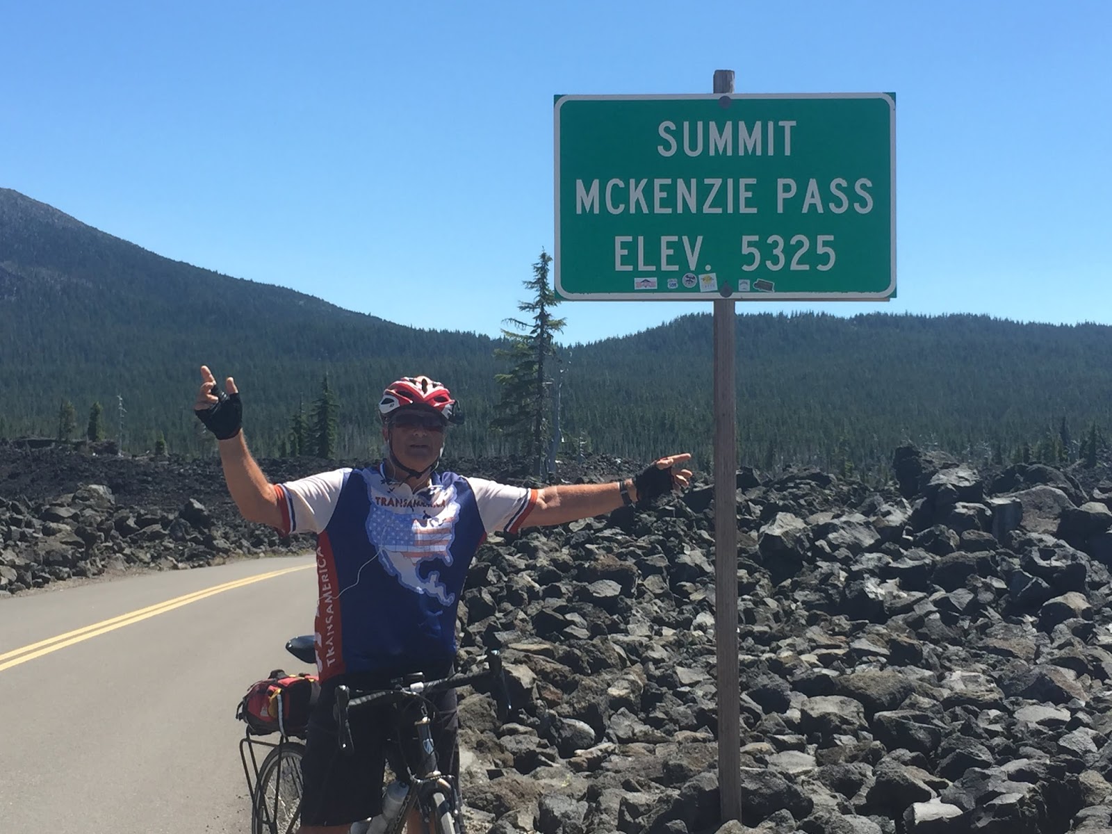
The ride up to the summit through the John Day Fossil bed area on the  Ochoco Highway (US 26) was spectacular. The climb begins about 30 miles in. Hard to believe that centuries ago this area was a tropical jungle inhabited by the rhinoceros, saber-toothed tiger, giant sloth, and the forerunner of today's miniature horse. The grade was low about 2%-4% most of the way. Just a 26 mile long slog up the pass. Was glad to see the top of Keyes Creek summit (4,382). The ride down was great. 

At 6 miles down we stopped in Mitchell. Only 10:50 but decided to have early lunch as nothing else until Prineville (48 miles and another even higher pass to go over!) About ten miles out of Mitchell the steady upward climb to Ochoco Summit began. Very long for hot afternoon and pretty consistent 6% grade for about 12 miles!! 

Based on the pictures Margie took the Ochoco Mountains were very scenic but my nose was to the pavement. Thank goodness for the frequent cold water stops. Don't think I could have carried enough water to get me over this one. Reached the summit about 2:15. Ride down to Prineville was 32 miles but seemed a lot longer. Was a steady gradual down grade, not the usual steep declines we've have had on other passes.

The 32 miles to Prineville seemed to take forever. Not surprising after 100 mile day with temps in the mid-nineties! Got to the Stafford Inn, our lodging for the night, at 3:45!  Happy for an air conditioned room and a cold beer!!


Starting at 5:18 am

Kind hazy sky due to forest fire

We can see the smoke as we get closer

Tanker trucks and helicopters

More copters

Scene in Dayville as firefighters head out

Firefighting camp


The road goes right thru the gap, very spectacular

Keys Creek Summit 4,284


Looks like a small volcano as you exit canyon

Taking a break with lemonade and ice cream

Interesting leaning rock formation

One of many water breaks on way up Ochoco Pass

Signs of recent forest fire

Victory! Ochoco Pass 4,720


Monday, July 6, 2015

Day 56 Baker City, OR to Mt Vernon, OR

Yorktown, VA to Mt Vernon, OR, Completed 3,780 Miles
Average 70 Miles/Day, Estimated Finish July 12, 2015

Biking Detail Phillips Lake, OR to Mt Vernon, OR
Day 56 Monday, July 6

Left the Lake Phillips area, 17 miles out of Baker City, at 6:45 AM.  Nice cool temperature and after some initial climbing enjoyed pretty ride through the flat Sumpter Valley area dotted with cattle ranches, deer grazing on the side of the road then heavy pine forests. 

Stillness of the morning is a great time to ride. Pretty much you and Mother Nature. Three passes on the docket today. Each separated by about 14 miles. Sumpter Pass (5,082) not too bad...pretty steady 6%-7%. Unmarked summit came sooner than expected and I enjoyed a nice ride down at 30-38 MPH. Grateful for no head wind this morning. 

Ride up to Tipton Pass (5,124) not bad either. Gentle 6-7% grades. Again, nice ride down!! Stopped at Austin Junction for short break before heading up the third pass. Turned on to US 26 going West and started the 7 mile upgrade. Again not a bad climb also at mostly at 2% to 4% with the last mile or so at 5%-6%. Got to the top of Dixie Pass (5,277) at 11:20....climbing done for the day and quicker than expected. More nice downhill'n! 

Stopped for iced coffee in Prairie City, only because espresso shops are few and far between! Beautiful green valley backdropped by the mountains...a constant reminder of more mountain passes to come as we continue West! Biked about ten miles past John Day to Mt Vernon before returning to the Daydreamer Motel, where we are staying for the night.


Top of Sumpter Pass 5,082 ft looking at Blue Mountains


Logging trucks back on road, this one heading the other way

Ok, not sure what this government sign means, we're in the middle of nowhere

Enjoying the 7 mile ride downhill


Second summit, Tipton Pass 5,124


Valley is nice and green

Third Pass, Dixie 5,277

More mountains ahead, and hazy due to forest fires

Down on the flats heading to John Day, OR

Scenery changes again


Small farms

Horses


Our Motel for the night in John Day, OR